Tuesday, 23 August 2016

FORT WILLIAM & BEN NEVIS

CALEDONIAN CANAL AT FORT AUGUSTUS

BY LOCH NESS

COMMANDO MEMORIAL AT SPEAN BRIDGE

GLEN NEVIS

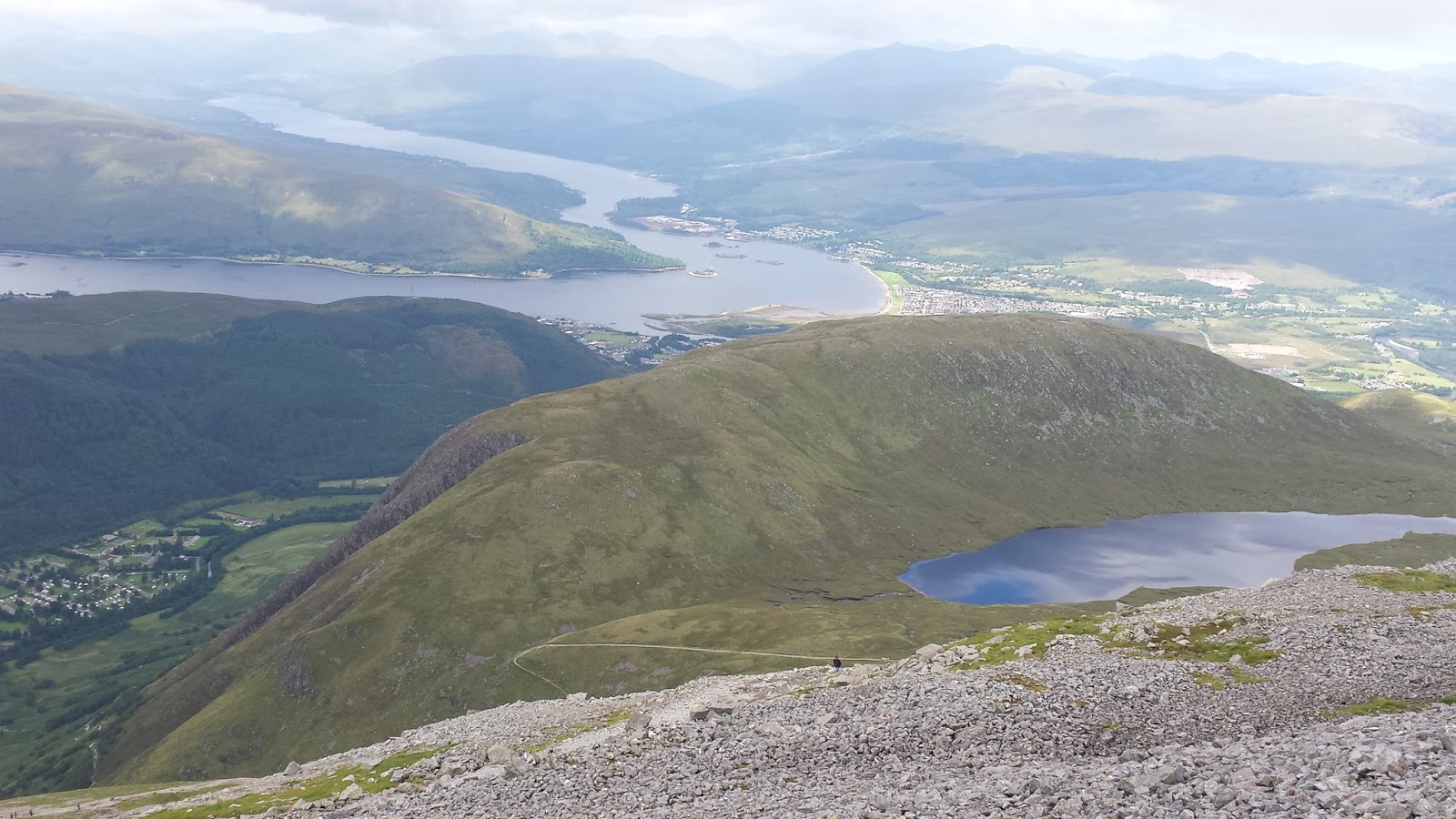
ABOVE HALFWAY LOCH ON BEN NEVIS

BEN NEVIS SUMMIT

THE OTHER SIDE OF BEN NEVIS

BEN NEVIS SUMMITEER OR IS THERE SUMMAT 'ERE?

A WELCOME INN ON OUR RETURN

POSER

ANOTHER POSER

Monday 8th of August, and we awoke from our loch-side slumber to find that the wind and dropped and the rain had ceased, just as hoped.

A short drive took us back to Fort Augustus. This picturesque small town is located at the southern end of Loch Ness. A section of the Caledonian Canal, which links Loch Ness to Loch Lochy, also passes through here. We watched boats progressing slowly through the five locks, then wandered about for a while until it was time for lunch. Rubi made some delicious fried egg and onion sandwiches.

Annoyingly,my smartphone had started to misbehave so I hoped there might be a shop where it could be repaired in Fort William, the largest town in the area and our next destination. When we set off to get there, we found our progress impeded somewhat by three bridges over the Caledonian Canal which were open to allow boats through when we reached them, and a car accident that blocked one lane. We also stopped briefly at the Commando Memorial near Spean Bridge.

We eventually parked in Fort William and headed for the busy High Street. There was a mobile phone repair shop in the town, but alas, it was closed when we got there. We consoled ourselves with supper and a drink at the first Wetherspoon's we had seen for a while.

We did consider booking a room at the nearby Travelodge, but when they told us that the price was more than £130 per night we went off the idea. Scotland seems to be so popular at this time of year that they can clearly charge what they like. We found ourselves a quiet lay-by along Glen Nevis instead, with glorious views of the mountains.

We intended to rise at 7.00am, but somehow it ended up 9.00am instead. It was our intention to walk to the 1,344m summit of Ben Nevis, so we packed up quickly and drove to the Ben Nevis Visitor Centre to check the latest weather forecast. Confirming that it was satisfactory, we prepared a packed lunch, grabbed our walking poles and set off. Lots of other people were also climbing the mountain today.

The path to the top was obvious and well-trodden, but quite rocky. As we climbed we were treated to great views along Glen Nevis. Then we reached Lochan Meall an t-Suidhe, also known as the 'Halfway Lochan', although it is actually a little less than that. After this, the climbing, though not technically difficult, became increasingly tiring and relentless.

As we neared the top we found ourselves in thickening fog, although we did get views when it cleared for brief moments. At last we could see the trig point marking the summit, where we took the mandatory photographs.

It was minus one degree Centigrade on the top and our fingers were hurting so it wasn't long before we were heading down again. Not until we had descended by about 500m did we consider it warm enough to stop and have our picnic lunch - rather late in the day as it was past 4.00pm by now.

The remainder of the descent was as long and relentless as the ascent, just a little less tiring. Around 6.00pm we reached the Ben Nevis Inn, just before the Visitor Centre, where we stopped for a drink.

Back at the car, we drove to our previous night's parking spot to find another camper already there in a German registered Volkswagen. There was still room for us too, so we parked up and made supper. Shortly afterwards, another car stopped alongside us, the driver got out and he politely told us that we had to move on as we were not allowed to camp in the Glen. We had obviously got away with it the previous evening. The other camper was also told to move on, but before she departed she suggested to us that we might want to consider parking near Old Inverlochy Castle, where she had done for several days running. We thanked her, took her advice, and had an undisturbed night.

In the morning we walked around Old Inverlochy Castle, which was quite small and a bit of a ruin, although there was clearly some restoration going on. Then we drove to the local Leisure Centre where, for a small fee, they let us use their showers. We left the car in their car park while we had a last look around the shops in Fort William and bought some food supplies. We found the mobile phone repair shop open this time, but all they offered to do was reset the phone to factory settings, which would delete the directory and all the photographs. This was a bit too drastic so I declined in the hope that I could find a better solution when I got home.

It was raining again, and this was expected to be the case for the rest of the day and tomorrow. It was time to continue our journey south so we drove on to Glencoe. We stopped at the Glencoe Visitor Centre where they had huge amounts of information about the local geology, history and wildlife. There was also much about the development of rock climbing techniques, and the personalities involved, and they had a film presentation about the 1692 massacre of the MacDonalds at Glencoe.

Back in the car, we drove further south on increasingly busy roads, passing by or through many places I had visited a decade ago when I walked the West Highland Way, such as Bridge of Orchy, Tyndrum, Crianlarich and Loch Lomond. Before long we crossed the Erskine Bridge and joined the fast moving traffic on the M8 and M74. It was a real change of pace from the easy-going motoring, often on single-lane roads, that we had enjoyed over the past two weeks.

It was starting to get dark so we needed to find somewhere to park for the night. We chose to turn off the motorway at Gretna Green and, after a little driving around, found a suitable place. This would be our last night in Scotland, but the holiday wasn't quite over yet.

SKYE'S COAST ROAD

SKYE'S OLDEST BAKERY

DUNVEGAN CASTLE

THE MUSEUM OF ISLAND LIFE

TRYING TO CHAT UP THE LOCALS

SHEEP SHELTERING FROM THE RAIN

THE QUIRAING

PORTREE CAFE

PORTREE HARBOUR

HYPNOTIC LOCH TARFF

In spite of the rain, we still appreciated the delightful morning view over Loch Dunvegan from our excellent roadside camping spot. Packing up quickly, we drove to Dunvegan village to replenish our food supplies. As we entered, we spotted a sign for ‘Skye's Oldest Bakery’ and stopped to buy some bread. On entering the shop, we saw that they served cooked breakfasts too. The temptation of eggs, bacon, sausage, fried bread, a bread roll and a pot of tea was too much to resist.

It was Saturday 6th and, according to the weather forecast, the weather was going to be poor all day. We therefore decided to drive around the coast of Skye, stopping at places of interest. Dunvegan Castle was first on our list. We had a look around the visitor centre, but thought that £12 each to go inside the Castle was rather expensive. One of the staff mentioned that we would reach an excellent viewpoint, from where we would see the Castle clearly, if we drove just a short distance along the road, so we did just that.

Continuing our route clockwise around the coast, our next stop was at Uig. Apart from the ferry port, there wasn’t very much here, but we did have a quick look around the pottery. Continuing onwards, we reached the ‘Skye Museum of Island Life’ in Kilmuir. This fascinating exhibition comprises six thatched stone houses, each one representing some aspect of life on Skye before transport and telecommunications changed things for ever. The Crofter’s house and the Smithy’s workshop were particularly interesting.

Soon we reached the northern-most point of Skye before the road took us south again. We had hoped to get our hiking boots on to visit a place called the Quiraing, an unusual rock formation caused by landslip, but the fog and sporadic rain made walking rather unappealing. We did, however, reach a viewpoint from where we could appreciate this exceptional place.

A little further south, towards Portree, we passed The Old Man of Storr, a rock pinnacle not far from the road which we had also hoped to get closer to, but it was shrouded in fog. In any case, it was getting late so we parked in a lay-by and tried to settle down for the night. Outside, the rain continued and the wind was powerful enough to rock the car. Sometime after 10.00pm, another car parked a short distance from us. Two men dressed in waterproofs got out, lit a barbeque and started to cook. We are not sure how they managed it with the barbeque flames almost horizontal. We left them to it and got to sleep.

Our hardy chefs were gone by the morning, but the wind and the rain hadn’t. We took another look at The Old Man of Storr, but all we could see was its grey form silhouetted against a slightly less grey sky. There was little option but to carry on down to Skye’s main town, Portree. Parking was free on Sunday, the shops were open and there were lots of visitors milling around.

We found the pleasant CafĂ© Arriba where we ordered spicy chick-pea soup and a cup of coffee, and chatted at some length to a couple of locals, one of whom groaned about how the town didn’t have the infrastructure to accommodate the number of tourists it receives. The poor weather was expected to continue for another 24 hours, so after a brief visit to the town’s harbour, we decided that it was time to leave Skye and head south towards Fort William. As we approached the Skye Bridge, it occurred to us that all the B&B’s and Guest Houses we had passed whilst driving around the island had displayed ‘No Vacancies’ signs. Either Skye is very popular at this time of year or the owners have taken a holiday elsewhere to get away from the dreaded midges.

Rubi wanted to see Loch Ness, so our journey to Fort William took us via Invermoriston and Fort Augustus. The rain was so heavy by the time we reached the latter that we decided there was little point in trying to look around the place. Instead, we chose to find somewhere nearby for the night and try again in the morning. Just a few miles up a minor road to the south of Loch Ness, we found a suitable spot right on the edge of Loch Tarff. As we cooked supper, the ripples coming towards us across the water seemed strangely hypnotic.

Sunday, 7 August 2016

THE CUILLIN HILLS

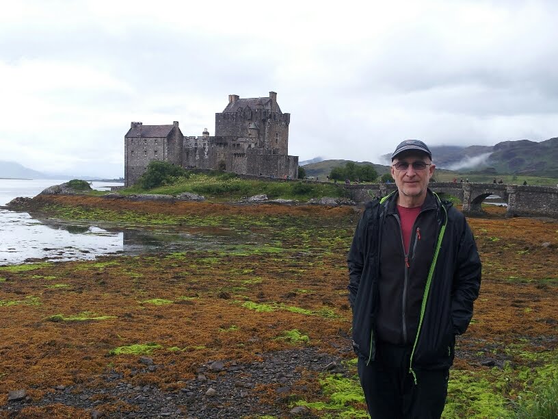
EILEAN DONAN CASTLE

EILEAN DONAN CASTLE & BRIDGE

FAIRY POOLS

SO THIS MUST BE A FAIRY?

LOOKING OUT FROM WATERPIPE GULLY

BEAUTIFUL CORRIE IN CUILLINS

TOO COLD TO SWIM IN

PATH ON THE CUILLIN RIDGE

NICE ARM CHAIR

'THE OLD INN' IN CARBOST

VIEWS OVER LOCH DUNVEGAN

Wednesday 3rd of August, and after a brief walk down to Gairlochy beach we continued south. We were heading for the Isle of Skye, but stopped off at the excellent Beinn Eighe Visitor Centre before turning off follow the A896 Wester Ross Coastal Trail, stopping for a tasty bowl of soup in the village of Torridon.

Next stop was Eilean Donan castle, one of Scotland's most photographed places. It is open to the public as a museum but also serves as a venue for wedding ceremonies. We enjoyed exploring this charming Scottish icon and learning about its history. It was also an ideal indoor activity given that it was pouring with rain much of the day.

Afterwards, we drove to Kyle of Lochalsh and crossed the Skye Bridge onto the island, continuing initially to Shigachan where we cooked supper for ourselves in the car. We subsequently found ourselves a place for the night in a car park along Glen Brittle, which runs north to south on the west side of the Cuillin Hills.

It took us a while to get going the following morning, but we eventually made our way to the start point of a path that runs alongside a stream called the Allt Coir' a' Mhadaidh up to the Fairy Pools. These are 'bowls' scooped out by waterfalls along the course of the stream, in which one can take a dip. The excellent weather had brought out many other people, a few of whom entered the water, but most just turned back after seeing the Pools. Following a tributary of the Allt Coir' a' Mhadaidh, we continued walking to where the Coire na Creiche steepened sharply up to the Cuillin ridge, where we found another pool. Rubi bravely had a paddle, but the freezing cold water ensured it was brief.

Rather than go back the way we came, we instead contoured around Sgurr an Fheadain so that we could get a closer look at Waterpipe Gully, which turned out to be amazing at close range - a deep fissure that runs right up to the top of the 688m high peak. We had a few slips and slides as we crossed a difficult scree slope to get there, but no injuries.

Further on, we reached the Allt Coir' a' Mhadaidh again where it exited at the base of Coire a' Mhadaidh and we followed it down over moorland until we got back to the Fairy Pools path. It was necessary to cross running water several times.

By the time we got back to the car we had been out for over 5 hours, but had really enjoyed our first foray into the huge and intimidating Cuillin Hills.

The sun was still shining so we drove down to the southern end of Glen Brittle and made supper whilst enjoying the views over Loch Brittle. There was a campsite nearby where we were able to replenish our water and buy some food, but to save money we returned to our car park for the night.

We were back at the campsite in the morning since it was the starting point for walks to the southern end of the Cuillin Hills. The weather was initially poor but gradually improved as we ate our breakfast. By walking through the campsite we were able to access a path which took us directly into a valley between Sgurr Dearg and Sgurr MhicChoinnich. The steady incline of the path steepened after a while and we scrambled over a rocky barrier. Beyond was a beautiful corrie enclosing a loch of blue water, like a land that time forgot.

The walls of the corrie were mainly scree slopes. Rubi remained by the loch with my rucksack and walking poles while I climbed up the scree to reach the summit ridge. This was a slow and tricky process as climbing loose scree inevitably causes rocks to be kicked down. It is wise to ensure that there is neither anyone above you nor below you.

Eventually I reached the ridge. It had been in clear view as I climbed, but was now shrouded in mist. I walked north along the ridge and had intended to reach a well-known rock called the Inaccessible Pinacle. However, the mist made routefinding tricky. Then it started to rain, which made the rocks slippery too. The atmosphere was really spooky and threatening. It was obviously wise to turn round and go back. Besides, Rubi had been waiting below long enough by now. I sent her an email and a text to let her know I was returning, but reception was poor so she got neither message.

Having memorised significant points along my route on the way out, I worked my way carefully back to the top of the scree slope and then skied down through the mist. Rubi had been patiently worrying and waiting for me near the now mist covered loch.

We returned to the campsite, chatting to a group of six from Washington State, USA, as we walked down. We then drove to Carbost at the northern end of Glen Brittle, picking up an Irish hitch-hiker along the way. We had passed each other at the top of the scree slope and he had recognised me.

There is a well-known pub and bunkhouse in Carbost, popular with outdoors people, called 'The Old Inn'. For £2 each they let us use their showers before we enjoyed a drink at the bar. Rubi had a whisky. The pub was heaving with dirty, sweaty cyclists and rugged bearded climbers.

After a shared bowl of skin-on chips, we left to find somewhere to stay near Dunvegan. We struck lucky, as usual, and found an ideal place for the night where we could watch the sunset over Colbost and Loch Dunvegan.

P.S. Did I tell you about the midges? Most people have heard about the agressive Scottish midges, but it is difficult to truly appreciate just how vicious they are until one has experienced being attacked by a swarm of them. For such a tiny insect, it is incredible how much their bites hurt, and we are both covered in little swellings as evidence. Rubi's face and neck seems to have been most attractive to them. They are most active morning and evening, e.g. when we have to leave the car to wash pans, clean teeth, etc. For prolonged exposure we have head nets, but even when returning to the apparent refuge of the car they follow you in. A quick spray of DEET inside the car seems to dispatch the interlopers, but we still wake up each morning with a few more bumps. Perhaps next time we will come to Scotland in the Winter when all we would have to contend with is freezing temperatures and snow.

Wednesday, 3 August 2016

SUILVEN

BLAIRMORE CAR PARK
WAR MEMORIAL AT LOCHINVER
LOCH-SIDE AT LOCHINVER
SUILVEN
TONY AT THE BOTHY
VIEW FROM SUILVEN
SUNSET FROM SUILVEN SUMMIT
MORNING CLOUD INVERSION FROM SUILVEN SUMMIT
TIME TO PACK UP
ON OUR WAY DOWN
With the exception of a shower, the facilties at Blairmore car park were almost as good as a camp site. It was past midday before we departed to drive south. What a drive it was though, weaving alongside lochs and around mountains. Wonderful new scenery presented itself to us each time we rounded a corner.

Our destination was Lochinver, by a route that took us past Scourie and Unapool. Rubi took over the driving at Scourie which meant that she had the exciting task of navigating the single track switchback which is the Assynt Coastal Route to Lochinver. It was hard to get above 3rd gear most of the time - and my car has 6 gears.

We arrived intact at our destination to be wowed by the view towards the harbour and out to sea. It was sunny for a change so we were able to take a mid-afternoon snack and cuppa at a picnic table beside the sea-loch.

We did a quick reconaissance of the area before paying a visit to The Caberfeidh Bar and Restaurant to enjoy tasty battered cod goujons washed down with, in my case, beer made from porridge oats. A chatty motorcyclist from Sheffield taking a random ride around Scotland, and a builder from Somerset, kept us company.

The weather was looking good for the next two days, so in the morning we packed our rucksacks for an overnight expedition to climb Suilven, a remarkable mountain because of its unique double-humped shape, like a camel's back. End-on, it seems to rise almost vertically out of the surrounding moorland, but it can be climbed from the side up to the dip between the peaks, although the route is still very steep. From there, each of the two summits can be accessed. The 723m high eastern one, called Meall Meadhonach, usually requires ropes to reach. However, the higher 731m western summit, Caisteal Liath, is accessible on foot, so this was our goal.

We parked the car near Glencanisp Lodge and started walking about 1.30pm. Roughly 3 miles further on we reached Suileag Bothy where we met Tony, from Christchurch, who was staying there temporarily. He was on the last week of a three week camping and fishing trip in the area.

Leaving Tony at 3.30pm, it took us another two and a half hours to reach the dip between the peaks, and another half an hour to reach Caisteal Liath. We were treated to the most stunning views across the moorland to adjacent mountains and the sea.

The wind was low so we made the decision to pitch the tent and stay the night on the summit. This enabled us to see a beautiful red sunset over Loch Inver.

In the morning we were treated to a further amazing sight as there was a carpet of clouds below us, called a cloud inversion, with the mountain peaks poking through.

The wind had risen a little during the night so we had to take care not to let anything blow away as we took down the tent and packed our rucksacks.

We returned by the same route we came, and it was a challenge to avoid slipping on the steep rocky slope down. Around 4 hours later we were back at Glencanisp Lodge. They had an Honesty Shop here (serve yourself and put the money in a box) so we made ourselves a welcome cup of hot chocolate.

We finally left Lochinver at around 5.00pm and continued our southerly journey, stopping briefly at Ullapool and eventually reaching Gairloch a little before 8.00pm.

To make a change from cooking in the car, we ate at the Millcroft Hotel in Gairloch before identifying a car park close to the beach as a suitable place for our stopover.

Sunday, 31 July 2016

DURNESS, CAPE WRATH & SANDWOOD BAY

WATERFALL INTO SMOO CAVE
CHOCOLATE HEAVEN
WHICH ONE IS MORE PRICKLY?
LOCAL EVENT
PIPE BAND
TOSSING THE CABER
KEOLDALE FERRY
CAPE WRATH LIGHTHOUSE
AWAITING THE FERRY BACK
THE FERRYMAN HAS BEEN DOING THIS FOR 33 YEARS
DUNES AT SANDWOOD
SANDWOOD BAY AND SEA STACK
The good thing about Scotland is that you can park your car or camper almost anywhere and spend the night in it, and nobody bothers you.

Our plan for Durness was to spend the day resting before embarking on a 3-day walk around the Cape Wrath peninsula with our tent. It was just as well that we were not going anywhere today since the weather was grim - relentlessly windy, and alternating between drizzle and heavy rain. The severity of the weather meant that the ferry across the Kyle of Durness, necessary to get to Cape Wrath lighthouse, was not operating. We spent the day washing our clothes, replenishing our food supplies and making full use of the local Visitor Centre.

In the evening we prepared our gear for the following day's walk to Cape Wrath, and slept in the car park by the ferry slipway at Keoldale ready to catch the 9.30am crossing. However, the morning's weather showed no improvement over the previous evening's and we were not surprised when the ferryman informed us that there would be no crossings today either. Nor would the ferry be operating tomorrow (Friday 29th) because of the annual local Highland Gathering.

Our plans thwarted, there was no option but to find other things to do. We had passed signs to Smoo Cave in Durness and went for a look. It was worth the effort to see this huge and fascinating place, with the Allt Smoo river passing through a hole in the roof of the cave to produce an impressive waterfall inside. We also walked out to the viewpoint to look north over the foggy Atlantic Ocean.

After, we took a drive to nearby Balnakeil Craft Village to see the paintings, pottery and glasswork. The village occupies buildings which were previously part of a cold war military early warning system, presumably for missiles coming over the North Pole. In the centre of the Village is the 'Cocoa Mountain' chocolate factory with a cafe serving the most exquisite, and expensive, hot chocolate. Rubi failed to show as much reluctance as I had hoped when I offered her one.

The weather had greatly improved by now, so we left the car at the Craft Village and took a 6 mile walk around the Faraid Head peninsula with its beautiful sandy beaches and dunes. From the Head itself we could just see Cape Wrath lighthouse to the west. Then it was back to the local Spar for supplies for our evening meal (a tasty mix of rice, ham, eggs and vegetables) before settling down for the night.

Friday was the day of the Durness Highland Gathering and the weather was cool but dry for it. The event is similar to the sort of village fete we have in the South of England, but with Scottish music and Highland Games thrown in. There were running and jumping events for all ages. Particularly exciting was watching burly Scotsmen putting the shot, throwing hammers and tossing the caber. The occasional poorly aimed or exceptionally good shot had everyone running for cover.

In one marquee they were promoting all sorts of Scottish foods including venison, rabbit, crab, smoked salmon and cod, wild garlic pesto, cheese and seaweed - with lots af samples for us to enjoy. Rubi was taking note of some of the recipes to make at home.

The music came from a folk band, various individual pipers and a full bagpipe marching band which finished off the event by playing Scotland the Brave.

Our last activity of the day was a pleasant walk along Sango Bay beach followed by our first whisky since arriving in Scotland. That helped us sleep!

We rose early on Saturday and rushed down to Keoldale in the hope that the ferry might take us across across the Kyle of Durness at last. We had also resolved to catch the minibus to Cape Wrath lighthouse rather than walk. When we arrived at the slipway, it was clear that many other people had had the same idea as there was quite a queue. Fortunately there were two minibuses waiting on the other side which could take a total of 32 people and we were numbers 29 and 30. Two young girls, numbers 31 and 32, arrived shortly after and those that came later were disappointed.

Once over the other side, we were treated to the slowest, bumpiest 11 mile ride that either of us had ever experienced. The road was little more than a track, but the hour it took to get to the lighthouse seemed shorter because of the amusing commentary from the driver. We saw lots of evidence of the military use of the area, including checkpoints, observation posts, gunnery targets and bomb craters. The lighthouse itself was little different to 
others we had seen, but the novelty came from being at the remote North Western corner of Scotland.

After refreshments in the very basic 'Ozone Cafe' at the lighthouse it was time to get back to the ferry. Rubi managed to wangle the front seats of the minibus for us both so that we had a much better view on our return journey.

Back at the car by 2.00pm, the weather was dry and we still had half the day left. We opted to drive down to Blairmore, near Kinlochbervie, so that we could walk to Sandwood Bay and back. The beach at Sandwood is reputed to be one of the most beautiful in Britain, and we were not dissapointed. Immediately behind the beach is a network of sand dunes which we explored. Just offshore is the well-photographed sea stack Am Buachaille rising out of the water. It was also noteworthy that we could see Cape Wrath lighthouse from the beach, just 11 miles away. Thus, even though we had not walked the whole route around the peninsula as originally planned, at least we had come to appreciate the magnitude and ruggedness of this remote wilderness area.

The 9 mile round trip to Sandwood Bay took us less than 4 hours, but after two great adventures in one day we were ready to eat and sleep. Tomorrow we would say farewell to the Cape Wrath area.